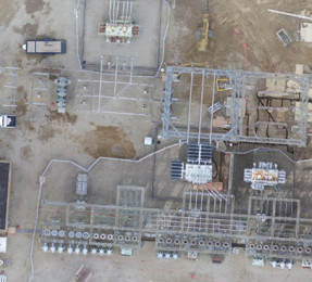
Micro-Scale Photogrammetry: UAS for Construction Monitoring
Point 1: Photogrammetry is not a new science. For hundreds of years, photogrammetry has been applied successfully across varied and vast geospatial extents to help users understand and analyze their environments. Point 2: Unmanned aircraft systems (UAS) allow for the quick and efficient acquisition of aerial imagery—the very building blocks of photogrammetry. A single UAS […]
Read More
CARTO Locations 2018 – A New Era of GIS
At their Locations conference in Brooklyn this year, CARTO set forth a new vision for their company and the GIS industry, as a whole. CARTO is moving away from “traditional GIS” and focusing their platform on what they call “location intelligence”. Traditionally, GIS has focused on visualization and calculation, but CARTO aims to be in […]
Read More
Accurate Navigation Coming to a Phone Near You
At last week’s Google I/O developer festival, engineers from Google’s Android location team previewed some exciting advancements coming soon to Android mobile devices. Two technologies will significantly improve location accuracies: Wi-Fi round-trip time (RTT) will enhance indoor location accuracy and enable indoor navigation. Global Navigation Satellite System (GNSS) will achieve sub-meter location accuracy outdoors in […]
Read More
Flying with the Big Boys at SAV
Last month, my team and I headed from Dayton, Ohio, down to Savannah, Ga., to fly our UAS at the Savannah/Hilton Head International Airport (SAV). Now, this is kind of a big deal. With F-35 fighter jets landing right beside us, our test UAS flights were some of the first to occur at a fully […]
Read More